

")


")

")


")

")


")


What actually is volcanism?

Basically, this question can be answered quite simply: A heat source and something that can melt through it - that is volcanism!
As with many things and phenomena, there is a definition for this that may seem a bit unwieldy: volcanism is a surface expression of internal heat on planets or moons, causing solid, liquid, or gaseous products to spread across the surface (Francis & Oppenheimer, 2004).
This definition allows us to consider volcanic phenomena throughout the solar system: silicate melts on Earth, sulfur lava on Jupiter's moon Io, "lava flows" of water on Saturn's moon Enceladus, or fountains of nitrogen on Neptune's moon Triton.
A volcano is therefore a place where material from the interior of a planet reaches the surface.
Literature
- Francis P. & Oppenheimer, C. (2004). Volcanoes. Oxford University Press. New York.

Phases of volcanism in the Vogelsberg
The simplified timeline shows the approximate duration of the volcanic phases. Before volcanism, the area of today's Vogelsberg was a flat landscape characterized by rivers and lakes (picture on the left).
Today the Vogelsberg is a gentle low mountain landscape (picture on the right).
In the upper part the colour coding shows the development of the climate: Red = tropical to subtropical climate, green = temperate climate.
The blue wedge gives information about the change of the relative precipitation amount (strongly simplified): Left = humid climate with high relative precipitation amounts, Right: moderate climate with lower precipitation amounts.
First volcanic phase

At the beginning of volcanism - about 18 million years ago - initially a landscape with a large number of individual volcanoes was formed, which only in the course of time developed into a closed volcanic field.
Volcanism in the Vogelsberg began with a first phase (bimodal main phase). During the ascent of the melt, it initially remained in magma chambers within the earth's crust for different lengths of time. Through this the original melts were changed (differentiated).
This process can be compared simplified with a snow globe: By shaking the ball, the small flakes distribute themselves relatively evenly. However, if the ball is no longer moved, the flakes fall to the bottom because they are heavier than the surrounding liquid.
Similar changes also take place in a magma chamber: The melt mixes with surrounding rocks, heavier components fall to the bottom and lighter ones rise to the top. This also happened during the first volcanic phase in the Vogelsberg, resulting in many different melts, which had different chemical and physical properties (differentiation series: trachybasaltic and trachyandesitic up to trachytic/phonolytic melts).
Thus, on the one hand, very thin-bodied lavas were brought to the earth's surface, which poured over relatively large distances over the subsurface at that time. On the other hand, other melts were very viscous and produced a partly highly explosive volcanism, which is still visible today in the form of block and ash flow deposits.
Resting phases and in-depth erosion
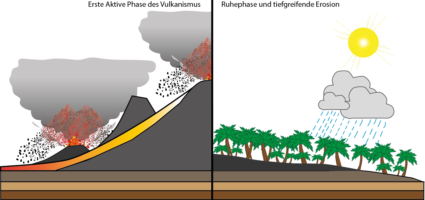
Already in the first volcanic phase there were periods of reduced activity in the Vogelsberg, during which erosion shaped the region.
About 17 million years ago the volcanic activity calmed down and the volcanoes, some of which were high towering and made of loose material, were deeply eroded. It is assumed that some of these volcanoes were several 100 to probably more than 1000 metres high.
At that time the area of today's Vogelsberg had a humid and tropical to subtropical climate. As a result, the volcanic structures were intensively weathered and almost completely eroded. Red earth, bauxite and basalt iron stone were formed, which were mined until the 70s of the 20th century and created an important industrial sector as well as an important source of income in the Vogelsberg. Further information on the role of ore and iron in the Vogelsberg can be found on the website of our geopark partner, the art tower Muecke.
Today, red earths are formed in the tropics, for example - in the Vogelsberg, however, fossil climate witnesses can be explored.
Second volcanic phase, the "chocolate casting"
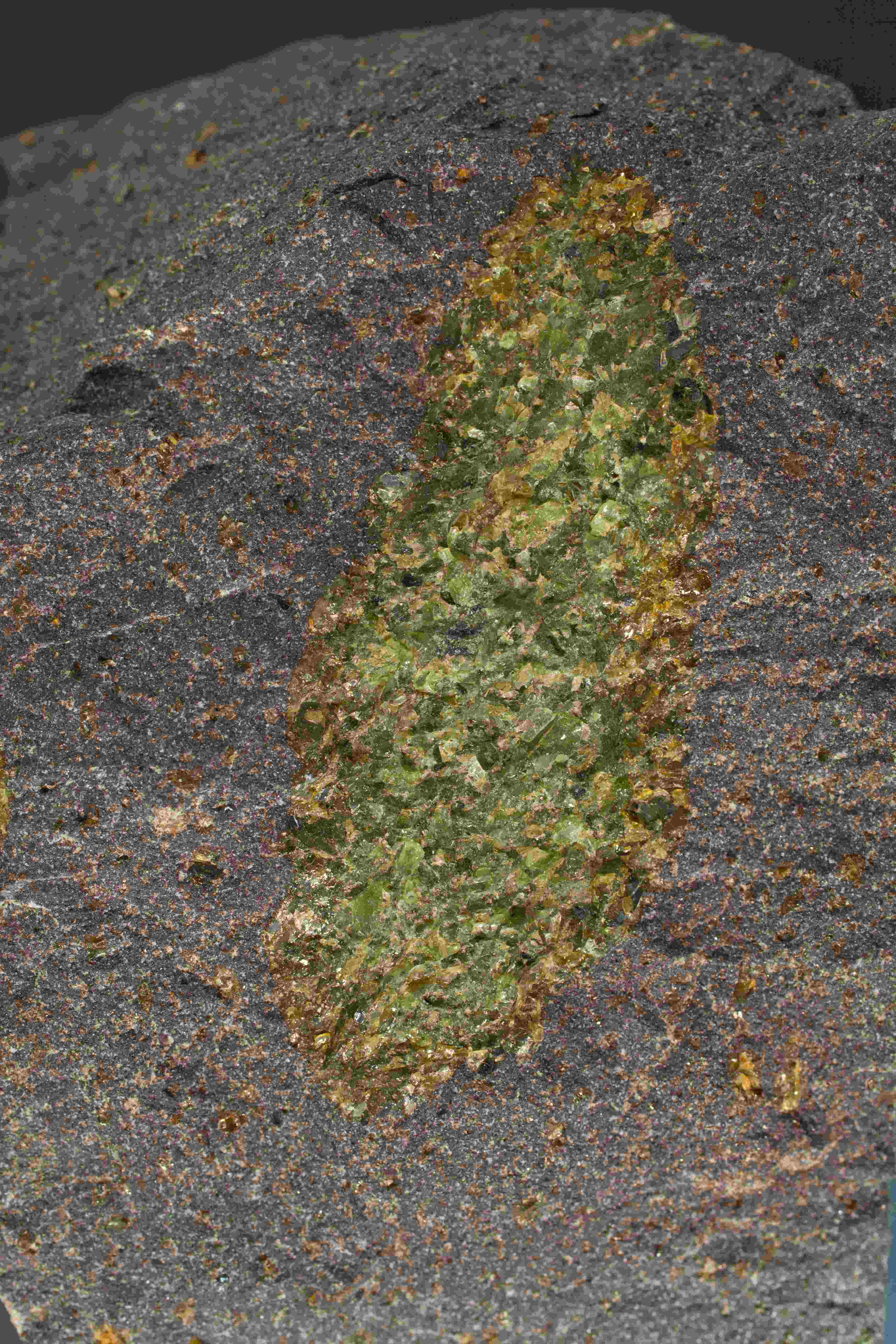
This eruption pause was followed by a second phase of volcanic activity that began about 15 million years ago. The magma produced was transported directly to the earth's surface without an "intermediate stop". Since this magma was not changed (differentiated), the chemical composition corresponded to that of the upper earth mantle (primitive).
During the rise of the magma, numerous fragments of the olive-green mantle rock (peridotite xenolithes) were torn upwards. The olive-green to brown crystals originate from depths between 60 and 80 kilometres. For comparison - the deepest borehole ever drilled by humans reached about 12 kilometres!
The "souvenirs" from the upper mantle can still be collected from the ground at various locations in the Vogelsberg today. The magmas (alkali basalt and basanite) smashed through the largely eroded volcanic structures of the first phase and covered them like a "chocolate cast".
Even today, these volcanic deposits still shape the appearance of the Vogelsberg, because by the end of the second activity phase a rather moderate and drier climate had set in about 16 million years ago, which meant that the rocks were no longer so severely eroded by the forces of weathering. The volcanic deposits from this phase still reach a thickness of more than 100 metres. After the end of volcanism in the Vogelsberg about 15 million years ago, levelling areas were created by extensive erosion, which were cut and interrupted by streams and rivers.
Versatile Vogelsberg
In addition to the phases of volcanism in the Vogelsberg described above, its diverse eruption types are also characteristic: there were cinder cones that were built up by volcanic products (pyroclastics). In addition, the contact between groundwater or surface water and ascending magma produced some violent explosions, which caused large funnel-shaped cavities to be blown into the subsoil. This resulted in pyroclastic deposits (tephra) of volcanic ash, lapilli and bombs. These deposits were partially solidified and can still be visited today in the Vogelsberg. Cinder cones are typical volcanic structures for this.
After the magma has been degassed as far as possible, the hot, thin lava (pahoehoe) can pour over the subsoil and basaltic deposits form. Younger ones overlap older basaltic witnesses of this process - like the layers in a cake.
The Vogelsberg: Once over 1000 meters high?
After the end of the volcanically active phase, the Vogelsberg was extensively eroded. The volcanic structures, some of which were once mighty, were leveled and rivers divided the region.
In addition, the power of weathering created hilltops that still characterise the landscape today. These crests were often created by the ability of the rocks to weather to varying degrees. This is due to the structure of the rocks as well as their origin and composition.
Ultimately, no clear statement can be made about the former height of the volcanic structures in the Vogelsberg. Only a few deposits indicate that there must have been elevations in the past, which must have had a height of 1000 meters and more. Evidence of this was found during the evaluation of the drilling at Sichenhausen (2007). There are ash stream deposits, which only occur if a certain height relief was present. Comparable deposits to today were formed when hot material raced down the slope of a volcano and reached a speed of several 100 kilometres per hour.
This shows that today the Vogelsberg is missing several hundred meters of height. Weathering and erosion also gnawed at the elevations during active volcanism. However, this process intensified during the volcanic pauses and after the end of the volcanism.
In addition, before and during the volcanism, the entire area was lowered, especially in the central area, which meant that further altitude was lost.
However, an exact statement about the former altitude cannot be made.


Eiszeit?
During the Cenozoic Ice Ages, the Vogelsberg was not covered by glaciers, so that they did not contribute to the shaping of today's landscape. However, the glaciated area was affected by frost (periglacial).
During this time the radial valley network developed. This means that from a common centre the rivers and streams developed radially outwards. The Young Tertiary weathering products were almost completely eroded, but they were most likely preserved on the western edge of the Vogelsberg near the Main/Lahn watershed.
The physical weathering was effective in the Quaternary: This form of weathering decomposes the rocks by external physical forces, such as water, ice, wind or temperature fluctuations. The rock was destroyed, but its rock-forming minerals remain. Through this processing of the rocks, solifluction layers, solifluction debris and block oceans could form - these three terms refer to products of the rearrangement of rock material of different sizes: Loose rocks soaked in water were displaced from their original place of origin by slow flow on inclined ground, especially on permafrost. An example of such a "Blockmeer" (sea of blocks) is the lower Schwarzbach valley "Felsenmeer" - visitors can find it on the Geopath Schwarzbach valley.
Especially in the lower areas of the Lower Vogelsberg and the surrounding subsidence zones, such as the Wetterau, loess, a sedimentary rock transported and deposited by the wind, deposited itself, which produces very fertile soils. In favourable locations the loess reaches thicknesses of more than ten metres. With the transition to the Holocene almost 12,000 years ago, the time after the last glaciation period, i.e. also the time in which we live today, the soils and the natural vegetation present today developed.
Cause of volcanism
Violent processes initiated the beginning of volcanism in many areas of Europe during the Tertiary period. The geological past of the continent plays just as important a role as the formation of the Alps.
Europe's geological history
Europe's history spans some 500 million years - an unimaginably long period! The eventful development has left its mark on the continent. Europe is a kind of "patchwork rug" - made up of different parts that have been compressed, torn apart, folded and profoundly altered several times by the changing climate and the force of erosion. This led to major disturbances that cross the continent in different directions. Such disturbances represent weaker areas in the European crust.
They can simply be compared to cracks in a masonry: If, for example, tensions occur in the foundation of the wall, these cracks cause further propagation and thus weaken the bond of stones and ultimately the entire wall.
On a continental scale, this means that disturbances are linked to the formation and ascent of magma.
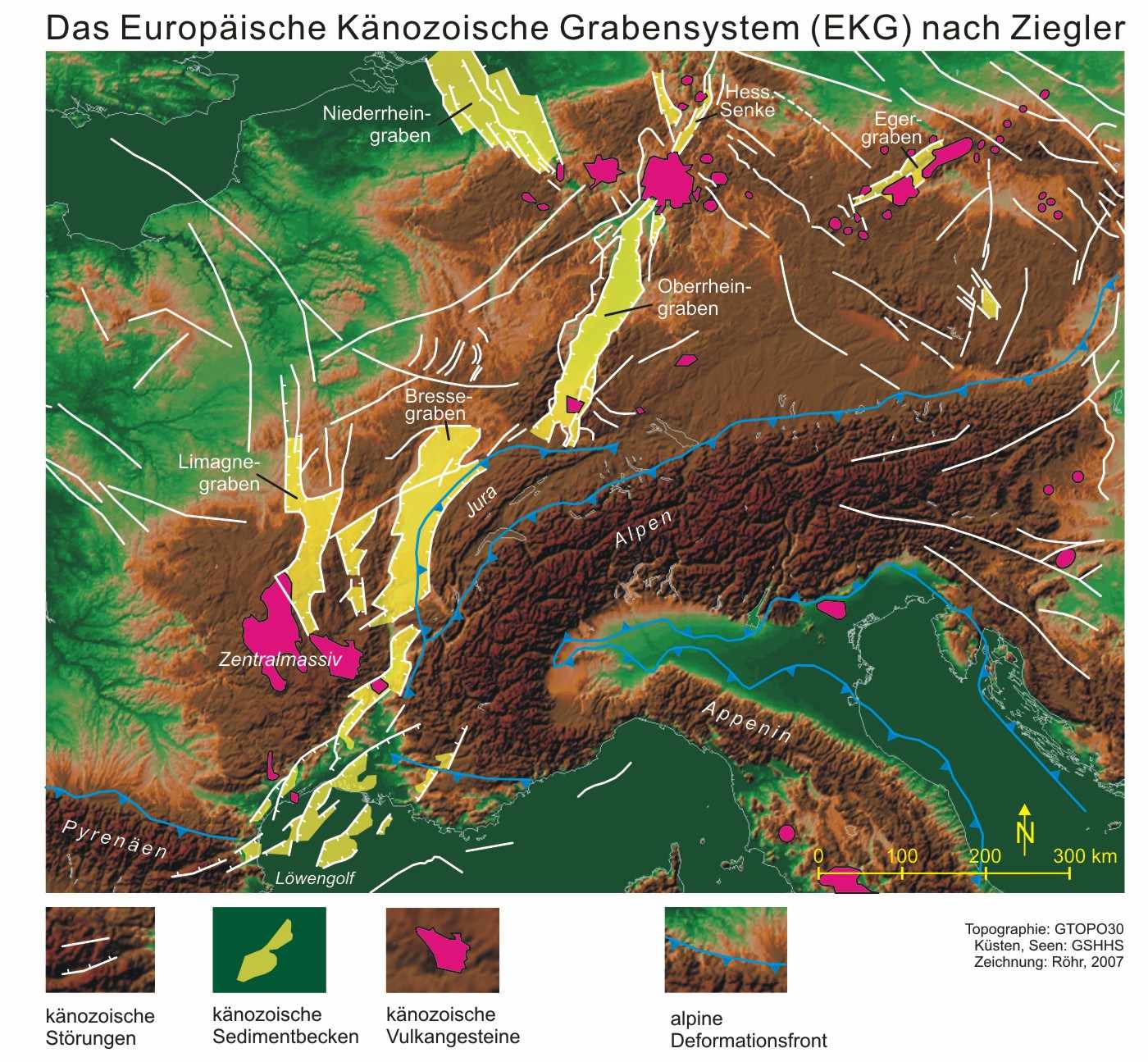
Why is the Vogelsberg exactly where it is?
The origin of the Vogelsberg volcanism has not been clarified for definite. There are various models and theories that are discussed in the scientific community.
The volcanism in the Vogelsberg is probably closely related to its position - at the intersection of two weak zones: The southwest-northeast running Taunus southern edge disturbance and the Upper Rhine Rift Valley, which is simply oriented from south to north and is part of a disturbance that crosses the continent from south to north.
The formation of the Alps was a major cause of volcanism: the movement of the African Plate towards Europe caused these two continental plates to collide, forming an entire mountain belt. This belt runs through large parts of Europe and Asia. The Alps are part of this belt. In the event of collisions between brittle and bulky objects, fractures and cracks cannot be avoided - this also applies to the European crust. Since the emergence of the mountain belt and the Alps in particular, the European crust has been deformed, resulting in Cenozoic volcanism in several places in Europe. The cracks and fractures in the European crust lead to melt formation and rise to the surface. The Vogelsberg is part of this system (see map).
Volcanism in the solar system

A very small digression!
In the past 30 years, space probes have provided numerous indications that volcanism is a phenomenon that occurs throughout the solar system. The detection of basalt on the Moon was already remarkable, but the astonishing discovery of permanent eruptions on Jupiter's moon Io forced researchers to question their previous thinking: volcanism is a process that can be observed on different planets and moons in the Solar System.
Literature
- Ehrenberg, K.-H. & Hickethier, H. (1985). Die Basaltbasis im Vogelsberg. Schollenbau und Hinweise zur Entwicklung der vulkanischen Abfolge. Geol. Jb. Hessen (113), 97–135.
- Francis P. & Oppenheimer, C. (2004). Volcanoes. Oxford University Press. New York.
- Leßmann, B., Scharpff, H.-J., Wedel, A., Wiegand, K. (2000). Grundwasser im Vogelsberg. Hessisches Ministerium für Umwelt, Landwirtschaft und Forsten; Hessisches Landesamt für Naturschutz, Umwelt und Geologie (Hrsg.). Wiesbaden.
- Leßmann, B., Wiegand, K. und Scharpff, H.-J. (2001). Die Hydrogeologie des vulkanischen Vogelsberges. Geologische Abhandlungen Hessen, Bd. 108, Wiesbaden.
- Nesbor, H.-D. (2014). Der Vogelsberg – Vulkanologische und petrologische Entwicklung eines großen miozänen Intraplatten-Vulkangebietes in Mitteleuropa. In H.-G. Röhling (Hrsg.), GeoFrankfurt 2014 Dynamik des Systems Erde / Earth System Dynamics. Exkursionsführer und Veröffentlichungen der Deutschen Gesellschaft für Geowissenschaften. (Vol. 252). S. 22–39. Hannover.
- Reischmann, T. & Schraft, A. (2009). Der Vogelsberg: Geotope im größten Vulkangebiet Mitteleuropas. Hessisches Landesamt für Naturschutz, Umwelt und Geologie. Wiesbaden.
- Roehr, C. (2007). Der Oberrheingraben. http://oberrheingraben.de/index.htm. Zugriff: 28.05.2019, 7:59 Uhr MEZ.